Knowledge of the pre-Flood world is limited because the Bible only gives a few details. Some creationists have relied heavily on secular interpretations in their studies on continental configurations and pre-Flood geography. ICR’s geological research is the first to tackle this issue using actual rock data from around the globe.
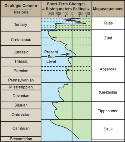
Most of the Phanerozoic rock record is divided into megasequences of deposition (Figure 1). Megasequences are discrete packages of sedimentary rock bounded on the top and bottom by erosional surfaces, often with coarse sandstone layers at the base.1 These packages were stacked one on top of another as each was sequentially deposited during the year-long Flood.
Our data set consists of over 1,500 stratigraphic columns from North America, Africa, the Middle East, and South America. Each rock column was compiled from published outcrop data, oil well boreholes, cores, cross-sections, and/or seismic data tied to boreholes. Rock type and megasequence data were put into a database, allowing thickness maps to be generated for all six megasequence intervals. These data were used to create a three-dimensional stratigraphic model across each of the three continents studied so far. When examined megasequence by megasequence, these models allow us to visualize the pre-Flood geographic relief.
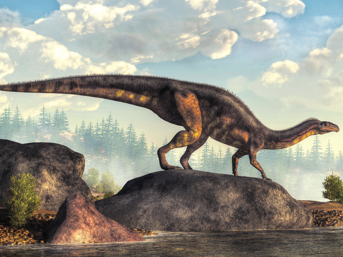
Earlier, we identified a pre-Flood land mass across the central United States that we labeled “Dinosaur Peninsula.”2 We found that the deposition of the earliest Flood sediments (the Sauk, Tippecanoe, and Kaskaskia Megasequences) was thickest in the eastern and far western U.S., including Grand Canyon. In contrast, the early Flood deposits across much of the center of the country are commonly less than a few hundred yards deep, and in many places there was no deposition at all (Figure 2). We concluded:
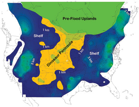
It seems the dinosaurs were able to survive through the early Flood in the West simply because they were able to congregate and scramble to the elevated remnants of land—places where the related sedimentary deposits aren’t as deep—as the floodwaters advanced.…In this way, dinosaurs were able to escape burial in the early Flood.2
The Pre-Flood World
Using the thicknesses of the various megasequence intervals, we made reasonable inferences about the relative topography of the pre-Flood world. We assumed the pre-Flood lows would be filled in first by the earliest deposits and the uplands later as the Flood levels increased, as described in Genesis 7. By comparing the megasequence data to the fossil record, we gleaned three broad environments—pre-Flood shallow seas, lowlands, and uplands, shown in Figure 3.
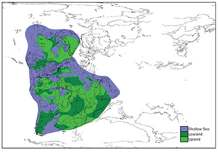
Shallow Seas
Results indicate shallow seas existed across much of the eastern and southwestern U.S. (including Grand Canyon) and across North Africa and the Middle East where the earliest three megasequences were deposited (Figure 1). The areas show extensive deposition of early Flood sediments and contain almost exclusively shallow marine fauna. There are virtually no trees or land animals in these megasequences. Apparently, only limited amounts of land were inundated at this stage in the Flood. We described this in detail in a recent peer-reviewed paper.3
Lowland Areas
During the deposition of the Absaroka Megasequence (Figure 1), the sediments began extending onto the land proper as water levels rose, starting with the lowland and wetland areas. This included the Karoo Supergroup across much of southern Africa and the Coconino Sandstone that extends across the southwestern U.S.
The first prolific deposits of coal (Pennsylvanian lycopod forests) and land animals mixed with marine flora and fauna also appear in the Absaroka. This indicates the Flood was now impacting significant amounts of pre-Flood land, such as the broad lowlands in East Africa and the central U.S., including Dinosaur Peninsula.
Upland Areas
All of the megasequences thinned toward the crystalline shield areas on each of the three continents. The sedimentary units do not merely show evidence of erosion and truncation, they become thinner in the direction of the shields—implying they were deposited on the flanks of extensive uplands.
Many of these interpreted upland areas are completely devoid of sedimentary rock because post-Flood erosion stripped the thin Zuni sediment that might have been deposited there. According to Genesis 7:20, the highest hills were only flooded by a modest amount of water, likely leaving little room for thick sedimentary deposits to accumulate. However, there are a few Zuni remnants in Hudson Bay and Michigan and Illinois that indicate the highest water level was achieved at this point in the Flood.
The lack of sediments preserved across the pre-Flood uplands may also help explain the lack of human fossils in the rock record. Most pre-Flood humans likely survived until close to Day 150 and probably congregated on the areas of highest ground. As the water levels crested on Day 150, humans were wiped off their higher gathering spots, and their bodies were washed away and transported in all directions. This process lessened the likelihood of finding any concentration of human fossils. It also made it less likely for them to be buried deeply enough in sediment to be preserved as fossils. And 4,500 years of post-Flood erosion would affect the highest strata the most. Any human remains buried in the uppermost feet of sediment most likely would have been eroded and destroyed.
Pangaea, Not Rodinia
Debate exists over the pre-Flood continental configuration, with some creation geologists advocating for an initial created supercontinent called Rodinia.4 However, we chose a slightly modified Pangaea because it has the most empirical geological evidence supporting it, including the best fit of the continents.5 We placed a narrow sea (300 km) between North America and Africa/Europe, allowing for limited plate subduction, an early Flood closure of the pre-Atlantic, and the formation of the Appalachian/Caledonian Mountains. The width of this pre-Atlantic is based on subducted plate remnants that diminish beneath the Appalachians below 300 km, supporting this narrow-sea interpretation.6
Another reason we favored Pangaea over Rodinia is that our current ocean floor was evidently created when the original creation week seafloor was consumed by subduction during the Flood event. It was the density contrast of the heavy, cold, original ocean crust (the lithosphere) that allowed the runaway subduction process to begin and continue. The density difference served essentially as the “fuel.” Geophysicist John Baumgardner described it as “gravitational energy driving the motion” of the plates.7 The “runaway” process continued until the original oceanic lithosphere was consumed. There was no geophysical means or reason to stop the rapid plate motion until the density contrast was fully alleviated. At that moment, the newer, more buoyant lithosphere ceased subducting, bringing plate motion to a virtual standstill. As a consequence, today we only witness small, residual plate motions of centimeters per year.
A pre-Flood world that resembled Rodinia would require the consumption of nearly all the pre-Flood ocean crust twice. The first time would be while the continents from Rodinia moved into the configuration of Pangaea, and then a second time when Pangaea split into the present global configuration. Geophysically, the first breakup of Rodinia and reconfiguration into Pangaea would be possible, but it would also consume all of the dense pre-Flood ocean crust. A second move would then be rendered impossible since any significant amount of new ocean crust created while splitting up Rodinia would not have enough density contrast to fuel a second episode of subduction. As mentioned above, it is the consumption of the cold, more dense pre-Flood ocean crust that caused runaway subduction in the first place.7 Therefore, if there had been a Rodinia, we would still be in a Pangaea continental configuration today.
Garden of Eden?
Many Christians have wondered if the current nation of Israel was the location of the pre-Flood Garden of Eden. Our maps demonstrate this is likely not the case. Figure 3 shows that an area of shallow seas probably existed across much of the Middle East, including Israel. Based on our research, the likely locations of the Garden are in what is now Canada, Brazil, West Africa, Asia, or even Greenland, depending on which direction was eastward of the place referenced in Genesis 2:8. The exact location of the Garden of Eden will likely never be known, but these results allow us to determine the major topographic highs and lows of the pre-Flood world. And it appears that the highest areas—the so-called shield areas—were the most likely locations of human habitation.
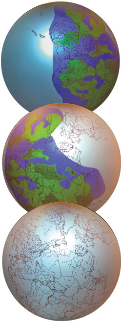
Discovery Center Globe
ICR will display our megasequence and pre-Flood maps on a 48-inch OmniGlobe projection system as part of an interactive exhibit in the ICR Discovery Center for Science and Earth History. Visitors will see the pre-Flood world continent by continent (Figure 4) and view the Flood’s progression as subsequent sedimentary megasequence layers were deposited, as well as supercontinent Pangaea’s breakup. This will be a valuable visual tool demonstrating the geological effects of the Flood as God’s judgment reshaped the world.
We are presently working our way across the continent of Europe to see what the data reveal there. Be sure to catch our results in future issues of Acts & Facts and on ICR.org.
References
- Sloss, L. L. 1963. Sequences in the Cratonic Interior of North America. Geological Society of America Bulletin. 74 (2): 93-114; Vail, P. R. and R. M. Mitchum Jr. 1979. Global Cycles of Relative Changes of Sea Level from Seismic Stratigraphy. American Association of Petroleum Geologists Memoir 29, 469-472.
- Clarey, T. 2015. Dinosaur Fossils in Late-Flood Rocks. Acts & Facts. 44 (2): 16.
- Clarey, T. L. and D. J. Werner. 2017. The Sedimentary Record Demonstrates Minimal Flooding of the Continents During Sauk Deposition. Answers Research Journal. 10: 271-283.
- Snelling, A. A. 2014. Geological Issues: Charting a scheme for correlating the rock layers with the Biblical record. In Grappling with the Chronology of the Genesis Flood. S. W. Boyd and A. A. Snelling, eds. Green Forest, AR: Master Books, 77-109.
- Clarey, T. L. 2016. Empirical data support seafloor spreading and catastrophic plate tectonics. Journal of Creation. 30 (1): 76-82.
- Schmandt, B. and F.-C. Lin. 2014. P and S wave tomography of the mantle beneath the United States. Geophysical Research Letters. 41 (18): 6342-6349.
- Baumgardner, J. R. 2016. Numerical Modeling of the Large-Scale Erosion, Sediment Transport, and Deposition Processes of the Genesis Flood. Answers Research Journal. 9: 1-24.
* Dr. Timothy Clarey is Research Associate at the Institute for Creation Research and earned his Ph.D. in geology from Western Michigan University.