Scenic places fascinate geologists, especially vistas that generate profound thoughts. Sometimes these thoughts challenge our customary ways of viewing our world. On my "top ten list" of favorite places on earth is Red Rock Pass, a little-known landform between two rather unimportant mountain ranges in southern Idaho. Located nine miles east of Interstate Highway 15 on the route north to Pocatello and five miles south of the small farming town of Downey, Idaho, this remote landform commands my attention and challenges my thinking. I celebrate Red Rock Pass for being the collapsed dam and spillway through which an enormous Ice Age lake drained catastrophically. It was the source of the great Bonneville flood.
Evidence of Ice Age Lakes
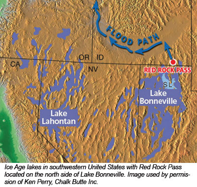
In Salt Lake City as I look eastward, I see on the western side of the Wasatch Mountains an ancient wave-eroded bench 800 feet higher than the city. That widespread bench was formed by erosion at 5,050 feet above sea level. It marks the old shoreline ("bathtub ring") of ancient Lake Bonneville, the largest Ice Age lake to form within the Great Basin. This old lake was comparable in volume to Lake Michigan, and occupied almost 20,000 square miles in eastern Nevada, western Utah, and southern Idaho. The surface of Lake Bonneville was about one third of the area of Utah. This massive lake attained a maximum depth of 1,000 feet and was 800 feet deep over Salt Lake City. It was among many other, smaller Ice Age lakes of the Great Basin, other noteworthy examples being Lake Lahontan (over the city of Reno, Nevada) and Lake Manley (within Death Valley, California).
Another widespread wave-eroded bench can be seen at elevation 4,710 feet (340 feet lower than the old Lake Bonneville shore). This lower "bathtub ring" marks the old shore of Lake Provo. Below the Provo shoreline, multiple old shorelines retreat downward to the present level of the Great Salt Lake (elevation about 4,210 feet). The wetter conditions of the post-Flood Ice Age allowed big lakes to exist within the Great Basin. The present Great Salt Lake is the nearly dried-up remnant of Lake Provo.
A Catastrophic Event
Still looking east from Salt Lake City, I see no other shoreline evidence between the level of old Lake Bonneville (5,050 feet) and the younger Lake Provo (4,710 feet). It appears that Lake Bonneville emptied abruptly, releasing 340 feet depth of water to reach the lower level of Lake Provo. Terrain analysis of the shorelines of both lakes indicates that the drainage of Lake Bonneville released about 850 cubic miles of water to become Lake Provo.1 Where did this water go? Did it drain in a single event?
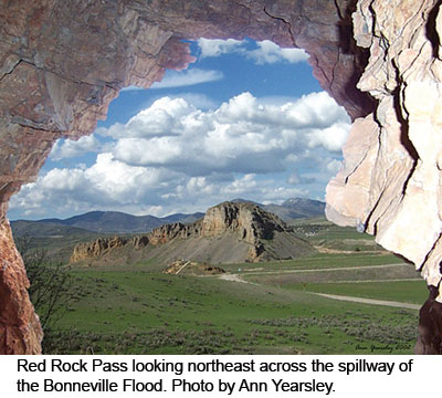
Proceeding northward from Salt Lake City back to Red Rock Pass in Idaho, I observe the old spillway of Lake Bonneville's catastrophic outlet flood. At Red Rock Pass, the spillway has an elevation just above 4,700 feet, which is the elevation it should have to retain old Lake Provo after catastrophic drainage of Lake Bonneville. Evidently, the old sedimentary bedrock dam at Red Rock Pass was once as high as 5,135 feet, holding back the water of older Lake Bonneville. Erosion of more than 340 feet of bedrock was accomplished very rapidly by the catastrophic release of 850 cubic miles of water from Lake Bonneville. Viewing the prehistoric collapse and erosion of the dam at Red Rock Pass would have been an awesome sight!
Development of a Breach
At the beginning of the colossal prehistoric flood from Lake Bonneville through Red Rock Pass, the spillway first formed as the water level in the lake on the south side reached the 5,100 feet level of the dam. Water may have leaked underground through the dam (a process called "piping" that destroyed Teton Dam) or flowed over the top of the dam (a process called "overtopping"). A notch formed in the top of the dam as erosion occurred because of the massive potential energy within the high lake on the south side of the dam. As the notch in the dam got deeper, so did the discharge. Erosion accelerated as the notch widened to form the spillway. As the dam began to collapse, the spillway enlarged to three-quarters of a mile wide. At the flood's peak, water was released through the spillway at approximately 35 million cubic feet per second,2 more than 4,000 times today's normal flow on the Colorado River in Grand Canyon. The big flood likely lasted for several weeks.
We can follow the path of the Bonneville flood northward from Red Rock Pass into the Snake River of Idaho and Oregon to the Columbia River in Washington and Oregon. Just north of Red Rock Pass, giant gravel bars and flood-sculpted bedrock cliffs show the power and depth of flood deposition and erosion. Significant erosion channels and scour surfaces occur in hard volcanic bedrock on the Snake River plain.3 High silt deposits on the Snake River also indicate the level of this great Ice Age flood.
Breached Dams and Erosion
My experience with the evidence for the Ice Age flood of Lake Bonneville helped me understand other catastrophic erosion features associated with breached dams. My three favorite examples of such dams are:
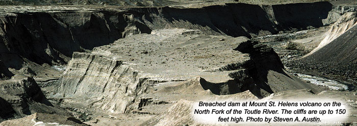
The breached dam at Lange's Crest on the upper North Fork of the Toutle River in Washington State--The mudflow from Mount St. Helens volcano on March 19, 1982, overtopped the debris dam that was deposited within the river valley in 1980. The mudflow eroded the rockslide and volcanic layers to a depth of 140 feet, forming a onefortieth scale "Little Grand Canyon" on the North Fork of the Toutle River.4
The ancient breached ice dam at Sandpoint, Idaho, that released Lake Missoula from Montana--Ice Age glaciers flowing southward in northern Idaho blocked the Clark Fork River, impounding about 500 cubic miles of water and forming a lake of 900 feet in depth over Missoula, Montana. The Lake Missoula flood began when the ice dam failed. The outburst flood destroyed the ice dam, eroding and scarring the 16,000-square-mile Channeled Scabland of eastern Washington. Fifty cubic miles of sediment were moved. Grand Coulee is the most prominent erosional feature (the 50-mile-long trench is one to six miles wide and averages 900 feet deep).5
The breached dam through the Kaibab Upwarp at Grand Canyon formed by drainage of large lakes in eastern Arizona, southeastern Utah, northeastern New Mexico, and western Colorado--Large lakes within the saucer-shaped depression of the Colorado Plateau appear to have contained about 3,000 cubic miles of water. The original breaching of the dam likely began by catastrophic drainage of ancient Hopi Lake in the eastern Grand Canyon.6
Ancient Lakes near Grand Canyon
My understanding and experience with catastrophic bedrock erosion at Red Rock Pass helped me to better appreciate Grand Canyon as a breached dam. While camping in eastern Grand Canyon with my geology graduate students in April 1985, we discussed the Bidahochi Formation, a large silt deposit at 6,000 feet elevation in northeastern Arizona. We were fascinated by the sedimentary evidence of a very large lake or lakes east and north of Grand Canyon as demonstrated by the silt deposit of the Bidahochi Formation.7 Could the erosion of a bedrock dam by drainage of 500 cubic miles of water from Hopi Lake have breached a channel at the location where we were camped in Grand Canyon?
A case could be made as we remembered Lake Bonneville's shoreline next to Red Rock Pass, only happening on a much larger scale in Grand Canyon. In 1986, I began the process of mapping the possible shore of the giant lakes east and north of Grand Canyon.8 In addition to Hopi Lake east of Grand Canyon, we recognized evidence for at least two large lakes in Utah. The largest of these lakes (what I call Canyonlands Lake9) was in northern Arizona, southeastern Utah, northeastern New Mexico, and western Colorado.
Darwin's First Wrong Turn
No discussion of the breaching of a 300-foot-high dam would be complete without remembering Charles Darwin's observations in Argentina in April 1834. After reading Charles Lyell's book Principles of Geology during his voyage on the Beagle, Darwin had 16 days to explore the valley of the lower Santa Cruz River. Darwin reported his interpretation of the valley in his journal:
At the first glance of the basaltic cliffs on the opposite sides of the valley, it was evident that the strata once were united. What power, then has removed along a whole line of country, a solid mass of very hard rock, which had an average thickness of nearly three hundred feet, and a breadth varying from rather less than two miles to four miles? The river, though it has so little power in transporting even inconsiderable fragments, yet in the lapse of ages might produce by its gradual erosion an effect of which it is difficult to judge the amount.10
His assumption of slow erosion of the river valley allowed Darwin to extrapolate "the lapse of ages" to speculation on organic evolution later in his voyage at the Galapagos Islands. Darwin became a geological evolutionist before he became a biological evolutionist. Some have called this uniformitarian thinking at the Santa Cruz River "Darwin's first wrong turn."
Today, geologists dispute Darwin's notion that the Santa Cruz River canyon was eroded by the daily activity of the normal river. Instead, many geologists today believe that large natural dams broke in the headwaters of the Santa Cruz River, releasing catastrophic floods from gigantic glacier lakes. Major excavation of the Santa Cruz River canyon occurred rapidly during catastrophic floods, not slowly through millions of years. If Darwin had known about the evidence of catastrophic breaching of dams within the upper drainage of Santa Cruz River, he might not have continued on to make his great extrapolation called organic evolution.11
When you visit an extraordinary place like Red Rock Pass in southern Idaho, expect to ponder some of the greatest issues of science!
References
- O'Connor, J. E. 1993. Hydrology, hydraulics, and geomorphology of the Bonneville flood. Geological Society of America Special Paper 274. 83 p. Some scientists estimate the volume of the Lake Bonneville flood exceeded 1,100 cubic miles.
- O'Connor, J. E. and J. E. Costa. 2004. The World's Largest Floods, Past and Present: Their Causes and Magnitudes. U.S. Geological Survey Circular 1254, 3.
- For a discussion of catastrophic erosion of bedrock by cavitation and macroturbulent flood flows, see: Baker, V. R. and V. S. Kale. 1998. The Role of Extreme Floods in Shaping Bedrock Channels. In Tinkler, K. J., and E. E. Wohl (eds.), Rivers Over Rock: Fluvial Processes in Bedrock Channels. Washington, DC: American Geophysical Union Geophysical Monograph 107, 153-165.
- Austin, S. A. 1984. Rapid Erosion at Mount St. Helens. Origins. 11:90-98. See also Footprints in the Ash: The Explosive Story of Mount St. Helens by Drs. John Morris and Steven Austin, available through ICR's online store or by calling 800.628.7640.
- See the made-for-television documentary Mystery of the Megaflood (2005, Public Broadcasting System), available as a DVD at the PBS website.
- Austin, S. A. (ed.). 1994. Grand Canyon: Monument to Catastrophe. Santee, CA: Institute for Creation Research, 284 pp. See especially pages 92 to 107 and endnote 40 on page 109.
- After the April 1985 Grand Canyon field study and lengthy discussions of the Bidahochi Formation, John H. Whitmore, one of my ICR graduate students, wrote a term paper titled "The Origin of the Colorado River Across the Kaibab Upwarp: Four Models" (October 7, 1985). With my encouragement, Whitmore's paper included a map of a large post-Flood lake in northeastern Arizona and text describing how flow from the lake breached the bedrock barrier known as the Kaibab Upwarp at Grand Canyon.
- In March 1986, I began public lectures on the rim of Grand Canyon on the "breached dam theory." In August 1986, I explained the significance of the Bidahochi Formation to Dr. Edmond W. Holroyd III and introduced him to the "breached dam theory" for the origin of Grand Canyon. I encouraged Holroyd to use a computer elevation database to plot possible shorelines of a very large lake or lakes, especially in southeastern Utah. Holroyd's computer plotting occurred in late 1986. By January 1987, Holroyd and I were exchanging maps we had drawn of Colorado Plateau lakes. Early in 1987, I used topographic data to show that if Grand Canyon were blocked today by a giant man-made dam with 5,700 feet elevation, the lake formed would rise behind the dam to a maximum of 5,620 feet elevation and would extend into four states. The overflow location out of that lake at 5,620 feet would be 20 miles east of Kanab, Utah, at Telegraph Flat. Holroyd and I discussed relict topography as evidences of the former lakes, especially topography around Glenn Canyon and Canyonlands in southeastern Utah. Holroyd published a verbal description of the search for lakes in an article titled "Missing Talus" in Creation Research Society Quarterly, June 1987, 21 (1):14-15. I published a rendition of a lake map (Arizona, Utah, Colorado, and New Mexico) in February 1989 (Grand Canyon Field Study Tour Guidebook, April 8-16, 1989, Santee, CA: Institute for Creation Research, 54).
- Austin, Grand Canyon: Monument to Catastrophe. See pages 103, 104, and endnote 62 on page 110.
- Darwin, C. 1839. Voyage of the Beagle. London: Smith, Elder. Quoting from chapter 9 under the entry dated April 26, 1834.
- You can explore the terrain that Darwin never saw: the extremely glaciated landscape with underfit rivers on enormous floodplains, huge glacially dammed lakes, and noteworthy breached structures. Use Google Earth software (available online) to view the upper Santa Cruz River near 50 degrees south latitude and 72 degrees west longitude.
* Dr. Austin is Consulting Geologist with Royale Energy.
Cite this article: Austin, S. 2008. Red Rock Pass: Spillway of the Bonneville Flood. Acts & Facts. 37 (7): 10.