Purpose
Is there geological evidence for a global flood? Is there evidence that the waters rose and peaked on Day 150 as recorded in Genesis 8? And at what level in the geologic record did it peak? ICR’s current geological research team has made one of the first attempts to map the true extent of the sedimentary rocks across all of the continents and provide answers to these questions.
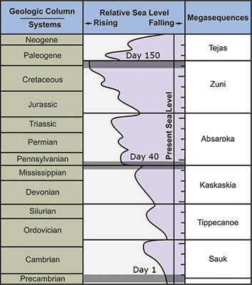
The fossil-bearing sedimentary rocks of the earth can be divided into six megasequences, or discrete packages of sediment (Figure 1).1 Megasequences can be thought of as massive pulses of waves that pushed across the continents during the Flood year. Each major pulse was followed by a minor withdrawal. The advance and withdrawal of each megasequence caused erosion at both the top and bottom of the cycle.
Methods
We have compiled over 3,000 stratigraphic columns from published outcrop data, oil well boreholes, cores, cross-sections, and/or seismic data tied to boreholes across North America, South America, Asia, Africa, and Europe. These data were input into a commercial software program that allows easy manipulation and compilation of the data set.
Results
Our results support a single, progressive global flood as described in Genesis. Individual megasequences reveal the exact step-by-step progression of the floodwaters. The rocks on every continent exhibit similar patterns of water-based deposition at about the same time, with even the fossils deposited in a very similar order.
The rock data show only limited flooding of the continents during the earliest three megasequences (Sauk, Tippecanoe, and Kaskaskia).2 The later three megasequences (Absaroka, Zuni, and Tejas) show much more surface coverage and volume of sediment deposited across each continent, indicating greater flooding. These data support that the Flood was progressive, peaking in the Zuni (exhibiting the most volume and surface extent) and receding in the Tejas.3 In terms of stratigraphy, the maximum flood level falls near the end of the Cretaceous (Figure 1). This global high-water level is interpreted as Day 150 in the Flood year.
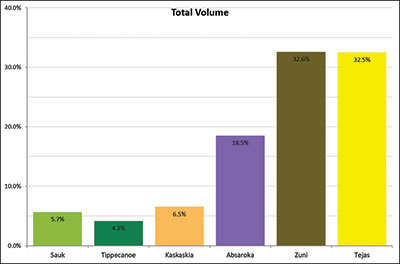
The Tejas contains the second-most sedimentary volume of any Flood megasequence, representing 32.5% of the total volume of rock deposited (Figure 2). We interpret the Tejas Megasequence as the rocks of the receding phase of the Flood, with much of this volume deposited along the continental margins. It includes the rocks formerly known as Tertiary (Paleogene and Neogene).
Impact
The consistency of the rock data across five continents confirms God’s Word.
The waters prevailed and greatly increased on the earth, and the ark moved about on the surface of the waters. And the waters prevailed exceedingly on the earth, and all the high hills under the whole heaven were covered. (Genesis 7:18-19)
The stratigraphic columns across each continent show a clear progression of the floodwaters, just as Genesis 7 describes. All of the continents exhibit limited amounts of flooding in the early Flood stages and then show progressively more and more deposition. The waters peak at nearly the same time and finally recede simultaneously (Figure 2).
There is no other reasonable way to explain these data. Simultaneous sedimentary patterns across five continents are strong evidence of the global Flood recorded in Genesis.
References
- Sloss, L. L. 1963. Sequences in the Cratonic Interior of North America. Geological Society of America Bulletin. 74 (2): 93-114.
- Clarey, T. L. and D. J. Werner. 2017. The Sedimentary Record Demonstrates Minimal Flooding of the Continents During Sauk Deposition. Answers Research Journal. 10: 271-283.
- Clarey, T. 2020. Carved in Stone: Geological Evidence of the Worldwide Flood. Dallas, TX: Institute for Creation Research.
* Dr. Clarey is Director of Research at the Institute for Creation Research and earned his Ph.D. in geology from Western Michigan University.